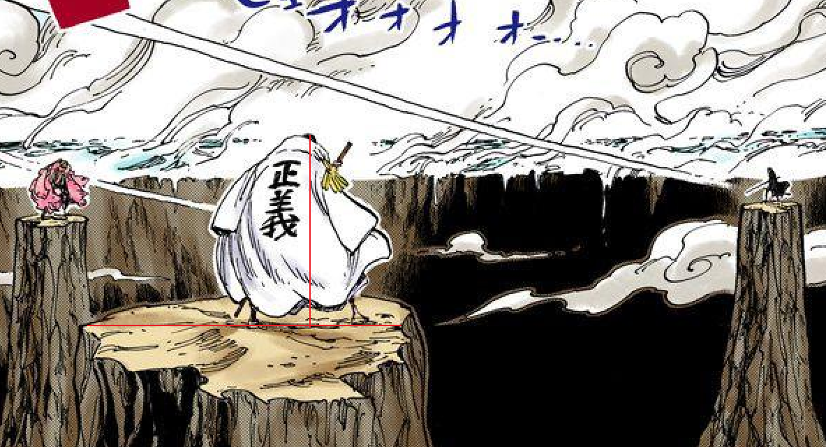
I just noticed (someone else noticed) via WrongIdea21's calc.
The assumption that you made that that's the entire island is just wrong.
In the overhead shot, the bridge is in the middle of the island, but in the picture you used, the bridge now apparently is on the far right?
So using what WI21 calced and assuming that it's half the island is valid, plus the fact that it's not the full island half since we can't see the rest and they got 40km on a lowball.
Different levels of assumptions there. If an author states that a building is 5 meters tall, I wouldn't say that "we have to assume that their meters are the same as ours" unless there was some plausible reason not to.
Notice the first 5 words.
"Different levels of assumptions".
My assumptions aren't even bad. You just don't like them.
If we add those for your pixelscaling as well, sure.
Yours.
- Assumption 1
- Pixelscaling Step 1
- Assumption 2
- Pixelscaling Step 2
- Assumption 3
- Pixelscaling Step 3
- Assumption 4
- Pixelscaling Step 4
Mine
- Assumption 1
- Assumption 2
- Calculation 1
- Pixelscaling Step 1
- Assumption 3
- Pixelscaling Step 2
- Assumption 4
Yours > mine with steps.
The island scan isn't as bad as that, but I'm open to exploring other options.
No, it's even worse
That is most definitely the case.
All I see are the ends of the island, I can't even see the island in your panel.
How does that justify calcing a distance and using that to detirmine the size of everything else? Your 74 kilometer to 90 kilometer size of Dressrosa is far larger than other methods I've seen for it.
Don't bring up the 90 over and over so everybody can say "He used 90??? I can't agree with that". The 90 was using wind speed, which changed.
The
original accepted size of Dressrosa was 43.8037 km.
This
lowballed method of Dressrosa via WrongIdea21 (since we can't see the full size of the island) brought 41.821 km.
Kobster's calc of the currently accepted one from over 2 years ago brought us 27.48592 km.
Cin's recalc using the same exact method as the one above and the currently accepted one got 50.4856075061 km.
Rin recalced it using the same exact method as the one above and the currently accepted one got 31.234 km.
Literally every single calculation you've done for Dressrosa has gotten relative, if not lower than, 20km. You are the only person who has calced Dressrosa to under 20km on this wiki, and the moment we use a different method with lowballed assumptions and half of the island not accounted for, you get 20km exactly.
The one you just did is a lowball and if we fully account for everything like WrongIdea21 did (which they couldn't even do since we still have an unknown portion we can't account for) gets 41 km.
If I use 25 minutes for the speed I get 60 km. I'm planning on changing it to around that time since 5 minutes for those events is ridiculous.
The highest one outside of both of ours is 50km. The lowest is 27 km.
Mine w/ 25 minutes is 10 over.
Yours is almost 10 under.
Don't act like yours is flawless.
How do we know that the 7.5 km figure for the end of the bridge is accurate? How do we know that the 74+ km figure for Dressrosa is accurate?
You and 3 other people calculated the same size with the same exact panels and got results ranging from 17 km to 50 km.
I used math and a few panels to account for the maximum size we can actually visibly see and got 60-74 km.
Because the two variables aren't solid; they can change.
Ok?
Same can island size if you find another picture, just like yours and all the others with the 16.5 km error margin.

 vsbattles.fandom.com

 vsbattles.fandom.com


